Version History
Here you can find the changelog of Air Navigation Pro since it was posted on our website on 2016-09-28.
The latest version is 8.3.370 and it was updated on soft112.com on 22 April, 2024.
See below the changes in each version:
version 8.3.370
posted on 2024-04-18
Apr 18, 2024
Version 8.3.370
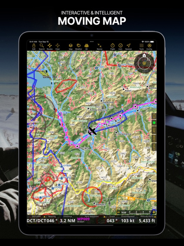
- Introducing Synthetic View: Our 3D View has received an upgrade with an improved UI and an integrated Moving Map preview!
- New Map Visibility Settings: Take control of overlapping maps by setting custom zoom level ranges, ensuring smooth transitions while zooming in and out.
- Enhanced Satellite Imagery: Smart Advanced subscribers now enjoy high-quality satellite views at higher zoom levels, while all other Smart plans gain access to regional topographical and satellite tile servers like Swisstopo, IGN, etc. Visit the Map Store to activate them for free!
version 8.3.361
posted on 2024-03-14
Mar 14, 2024
Version 8.3.361
- Expanded Cross-Platform Reach: Our app is now accessible across more platforms!
- Manager Service Upgrades: Operators using our Manager service will benefit from improvements introduced in the latest Manager 5.0 release.
- Visual Improvements: SmartChart's dark mode has been optimized for enhanced usability during night flights. Airspace border colors have been adjusted for better consistency with aviation standards and improved contrast in all color theme modes
- Bug Fixes: Bugs have been addressed for improved reliability.
Thank you for choosing Air Navigation Pro! Follow us on social media to stay up to date!
version 8.3.350
posted on 2024-01-08
Jan 8, 2024
Version 8.3.350
Happy New Year! Thank you for your continuous support for another year!
Check out what's new in this version:
- Map Annotations: Now, you can highlight, draw geometrical figures and write with a marker directly on the map, allowing you to create your own data like user airspaces. Activate it on Map Options - Guides and work in Edit Mode.
- Enhanced Map Resolution: We've boosted the resolution of the vector map at high zoom levels, ensuring a clearer navigation experience.
- Improved Dark Mode Handling: Switch effortlessly between Light, Dark or let the app adapt automatically. Find the new Color Theme menu on Map Options.
- Seamless Cross-Platform Synchronization: Enjoy a smooth experience between your mobile device and the new desktop version!
Start the year on the right track with our first update of 2024, because great journeys begin with great navigation!
version 8.3.301
posted on 2023-11-14
Nov 14, 2023
Version 8.3.301
- Fixed an issue with the 3D View
version 8.3.300
posted on 2023-10-25
Oct 25, 2023
Version 8.3.300
- Lock the movement of the map by long-pressing on the compass rose
- In the context of releasing a new Air Navigation version for a new platform, we have fixed bugs and improve the overall performance of the application.
version 8.3.207
posted on 2023-08-26
Aug 26, 2023
Version 8.3.207
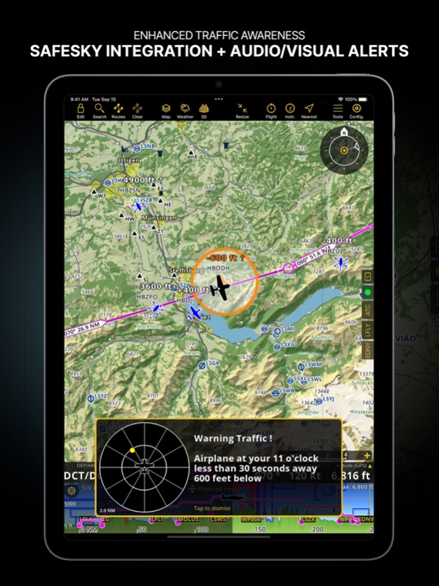
- The subscription model has been simplified and improved. Choose now between three subscription plans that include everything you need to fly. Internet traffic is now available in all new subscription plans thanks to our partnership with SafeSky.
- Traffic display has been improved: Choose among three different display styles. On top of that you can enable now visual and audio warnings.
- Austrian GAFOR and GAFOR for the balkans (eGAFOR) now available
- Smart Advanced subscribers can now import maps (mbtiles and geoTIFF files supported)
- Bug fixes and other improvements.
version 8.3.206
posted on 2023-08-12
Aug 12, 2023
Version 8.3.206
- The subscription model has been simplified and improved. Choose now between three subscription plans that include everything you need to fly. Internet traffic is now available in all new subscription plans thanks to our partnership with SafeSky.
- Traffic display has been improved: Choose among three different display styles. On top of that you can enable now visual and audio warnings.
- Austrian GAFOR and GAFOR for the balkans (eGAFOR) now available
- Smart Advanced subscribers can now import maps (mbtiles and geoTIFF files supported)
- Bug fixes and other improvements.
version 8.3.204
posted on 2023-07-07
Jul 7, 2023
Version 8.3.204
- The subscription model has been simplified and improved. Choose now between three subscription plans that include everything you need to fly. Internet traffic is now available in all new subscription plans thanks to our partnership with SafeSky.
- Traffic display has been improved: Choose among three different display styles. On top of that you can enable now visual and audio warnings.
- Austrian GAFOR and GAFOR for the balkans (eGAFOR) now available
- Smart Advanced subscribers can now import maps (mbtiles and geoTIFF files supported)
- Bug fixes and other improvements.
version 8.3.203
posted on 2023-06-28
Jun 28, 2023
Version 8.3.203
- The subscription model has been simplified and improved. Choose now between three subscription plans that include everything you need to fly. Internet traffic is now available in all new subscription plans thanks to our partnership with SafeSky.
- Traffic display has been improved: Choose among three different display styles. On top of that you can enable now visual and audio warnings.
- Austrian GAFOR and GAFOR for the balkans (eGAFOR) now available
- Bug fixes and other improvements.
version 8.3.202
posted on 2023-06-17
Jun 17, 2023
Version 8.3.202
- The subscription model has been simplified and improved. Choose now between three subscription plans that include everything you need to fly. Internet traffic is now available in all new subscription plans thanks to our partnership with SafeSky.
- Traffic display has been improved: Choose among three different display styles. On top of that you can enable now visual and audio warnings.
- Austrian GAFOR and GAFOR for the balkans (eGAFOR) now available
- Bug fixes and other improvements.
version 8.3.201
posted on 2023-06-12
Jun 12, 2023
Version 8.3.201
- The subscription model has been simplified and improved. Choose now between three subscription plans that include everything you need to fly. Internet traffic is now available in all new subscription plans thanks to our partnership with SafeSky.
- Traffic display has been improved: Choose among three different display styles. On top of that you can enable now visual and audio warnings.
- Bug fixes and other improvements.
version 8.3.198
posted on 2023-05-06
May 6, 2023
Version 8.3.198
Bug Fixes
version 8.3.197
posted on 2023-04-24
Apr 24, 2023
Version 8.3.197
-Bug fixes
version 8.3.195
posted on 2023-03-19
Mar 19, 2023
Version 8.3.195
* Improved elevation profile: more information and functionalities
* Wind barbs on map and elevation profile
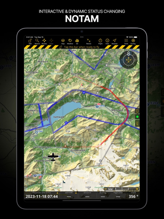
* Improved NOTAM display
* Styling of dynamic airspaces will now change depending their status
* Traffic patterns are now displayed on the map for selected countries. More to come soon.
* SmartChart improved to display worldwide forests, build-up areas, glaciers and more
version 8.2.002
posted on 2022-06-30
Jun 30, 2022 Version 8.2.002
An issue in the 'Installed Data' panel was fixed
version 8.2.000
posted on 2022-04-25
Apr 25, 2022 Version 8.2.000
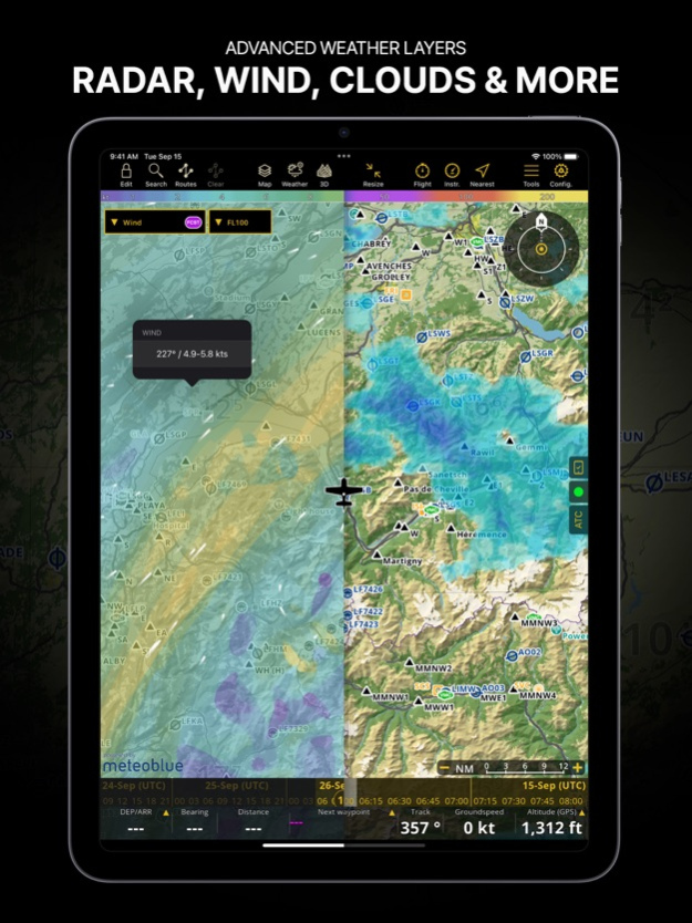
Included in all premium subscriptions: Graphical weather forecast, nowcast and measurement display on map such as wind, pressure, clouds, visibility, GAFOR, Radar
Bug fixes and performances improvements
version 8.1.700
posted on 2022-02-28
Feb 28, 2022 Version 8.1.700
Thanks for using Air Navigation Pro! We regularly update our app to fix bugs, improve performance and add new features to help you fly with the highest level of safety, awareness and pleasure at the same time.
Added ability to dim the map for elevation over a selected altitude
Various user interface improvements
version 8.1.670
posted on 2022-02-08
Feb 8, 2022
Version 8.1.670
Thanks for using Air Navigation Pro! We regularly update our app to fix bugs, improve performance and add new features to help you fly with the highest level of safety, awareness and pleasure at the same time.
version 8.1.555
posted on 2021-12-11
Dec 11, 2021 Version 8.1.555
Thanks for using Air Navigation Pro! We regularly update our app to fix bugs, improve performance and add new features to help you fly with the highest level of safety, awareness and pleasure at the same time.
version 8.1.554
posted on 2021-12-08
Dec 8, 2021 Version 8.1.554
Thanks for using Air Navigation Pro! We regularly update our app to fix bugs, improve performance and add new features to help you fly with the highest level of safety, awareness and pleasure at the same time.
version 8.1.553
posted on 2021-12-06
Dec 6, 2021 Version 8.1.553
Thanks for using Air Navigation Pro! We regularly update our app to fix bugs, improve performance and add new features to help you fly with the highest level of safety, awareness and pleasure at the same time.
version 8.1.551
posted on 2021-12-03
Dec 3, 2021 Version 8.1.551
Thanks for using Air Navigation Pro! We regularly update our app to fix bugs, improve performance and add new features to help you fly with the highest level of safety, awareness and pleasure at the same time.
version 8.1.504
posted on 2021-10-22
Oct 22, 2021 Version 8.1.504
Thanks for using Air Navigation Pro! We regularly update our app to fix bugs, improve performance and add new features to help you fly with the highest level of safety, awareness and pleasure at the same time.
version 8.1.503
posted on 2021-10-20
Oct 20, 2021 Version 8.1.503
Thanks for using Air Navigation Pro! We regularly update our app to fix bugs, improve performance and add new features to help you fly with the highest level of safety, awareness and pleasure at the same time.
version 8.1.502
posted on 2021-10-11
Oct 11, 2021 Version 8.1.502
Thanks for using Air Navigation Pro! We regularly update our app to fix bugs, improve performance and add new features to help you fly with the highest level of safety, awareness and pleasure at the same time.
version 8.1.501
posted on 2021-10-09
Oct 9, 2021 Version 8.1.501
Thanks for using Air Navigation Pro! We regularly update our app to fix bugs, improve performance and add new features to help you fly with the highest level of safety, awareness and pleasure at the same time.
version 8.1.500
posted on 2021-10-06
Oct 6, 2021 Version 8.1.500
Thanks for using Air Navigation Pro! We regularly update our app to fix bugs, improve performance and add new features to help you fly with the highest level of safety, awareness and pleasure at the same time.
version 8.1.460
posted on 2021-09-22
Sep 22, 2021 Version 8.1.460
Thanks for using Air Navigation Pro! We regularly update our app to fix bugs, improve performance and add new features to help you fly with the highest level of safety, awareness and pleasure at the same time.
version 8.1.450
posted on 2021-07-07
Jul 7, 2021 Version 8.1.450
Thanks for using Air Navigation Pro! We regularly update our app to fix bugs, improve performance and add new features to help you fly with the highest level of safety, awareness and pleasure at the same time.
version 8.1.410
posted on 2021-06-07
Jun 7, 2021 Version 8.1.410
Thanks for using Air Navigation Pro! We regularly update our app to fix bugs, improve performance and add new features to help you fly with the highest level of safety, awareness and pleasure at the same time.
version 8.1.406
posted on 2021-05-07
May 7, 2021 Version 8.1.406
Thanks for using Air Navigation Pro! We regularly update our app to fix bugs, improve performance and add new features to help you fly with the highest level of safety, awareness and pleasure at the same time.
version 8.1.405
posted on 2021-05-01
May 1, 2021 Version 8.1.405
Thanks for using Air Navigation Pro! We regularly update our app to fix bugs, improve performance and add new features to help you fly with the highest level of safety, awareness and pleasure at the same time.
version 8.1.402
posted on 2021-04-12
Apr 12, 2021 Version 8.1.402
Thanks for using Air Navigation Pro! We regularly update our app to fix bugs, improve performance and add new features to help you fly with the highest level of safety, awareness and pleasure at the same time.
version 8.1.301
posted on 2021-02-18
Feb 18, 2021 Version 8.1.301
Thanks for using Air Navigation Pro! We regularly update our app to fix bugs, improve performance and add new features to help you fly with the highest level of safety, awareness and pleasure at the same time.
version 8.1.300
posted on 2021-02-17
Feb 17, 2021 Version 8.1.300
Thanks for using Air Navigation Pro! We regularly update our app to fix bugs, improve performance and add new features to help you fly with the highest level of safety, awareness and pleasure at the same time.
version 8.1.100
posted on 2021-02-11
Feb 11, 2021 Version 8.1.100
Thanks for using Air Navigation Pro! We regularly update our app to fix bugs, improve performance and add new features to help you fly with the highest level of safety, awareness and pleasure at the same time.
version 8.1.070
posted on 2021-01-11
Jan 11, 2021 Version 8.1.070
Thanks for using Air Navigation Pro! We regularly update our app to fix bugs, improve performance and add new features to help you fly with the highest level of safety, awareness and pleasure at the same time.
version 8.1.002
posted on 2020-11-08
Nov 8, 2020 Version 8.1.002
Thanks for using Air Navigation Pro! We regularly update our app to fix bugs, improve performance and add new features to help you fly with the highest level of safety, awareness and pleasure at the same time.
version 8.0.270
posted on 2020-10-28
Oct 28, 2020 Version 8.0.270
Thanks for using Air Navigation Pro! We regularly update our app to fix bugs, improve performance and add new features to help you fly with the highest level of safety, awareness and pleasure at the same time.
version 8.0.250
posted on 2020-09-23
Sep 23, 2020 Version 8.0.250
Thanks for using Air Navigation Pro! We regularly update our app to fix bugs, improve performance and add new features to help you fly with the highest level of safety, awareness and pleasure at the same time.
version 8.0.210
posted on 2020-09-08
8 Sep 2020 Version 8.0.210
Thanks for using Air Navigation Pro! We regularly update our app to fix bugs, improve performance and add new features to help you fly with the highest level of safety, awareness and pleasure at the same time.
version 8.0.210
posted on 2020-09-08
Sep 8, 2020 Version 8.0.210
Thanks for using Air Navigation Pro! We regularly update our app to fix bugs, improve performance and add new features to help you fly with the highest level of safety, awareness and pleasure at the same time.
version 8.0.200
posted on 2020-09-01
Sep 1, 2020 Version 8.0.200
Thanks for using Air Navigation Pro! We regularly update our app to fix bugs, improve performance and add new features to help you fly with the highest level of safety, awareness and pleasure at the same time.
version 8.0.140
posted on 2020-08-24
Aug 24, 2020 Version 8.0.140
Thanks for using Air Navigation Pro! We regularly update our app to fix bugs, improve performance and add new features to help you fly with the highest level of safety, awareness and pleasure at the same time.
version 8.0.120
posted on 2020-08-17
Aug 17, 2020 Version 8.0.120
Thanks for using Air Navigation Pro! We regularly update our app to fix bugs, improve performance and add new features to help you fly with the highest level of safety, awareness and pleasure at the same time.
version 8.0.110
posted on 2020-08-06
Aug 6, 2020 Version 8.0.110
Improve the performance.
Enhance the visibly of some icons on the map.
version 8.0.100
posted on 2020-07-29
Jul 29, 2020 Version 8.0.100
Bug fixes and improvements
version 8.0.92
posted on 2020-07-17
Jul 17, 2020 Version 8.0.92
Worldwide map for subscribers.
Satellite view is included in the subscriptions.
version 8.0.91
posted on 2020-06-12
Jun 12, 2020 Version 8.0.91
Worldwide map for subscribers.
Satellite view is included in the subscriptions.
version 8.0.90
posted on 2020-05-22
May 22, 2020 Version 8.0.90
Worldwide map for subscribers.
Satellite view is included in the subscriptions.
version 8.0.86
posted on 2020-05-15
May 15, 2020 Version 8.0.86
Worldwide map for subscribers.
Satellite view is included in the subscriptions.
version 8.0.84
posted on 2020-05-12
May 12, 2020 Version 8.0.84
Worldwide map for subscribers.
Satellite view is included in the subscriptions.
version 8.0.80
posted on 2020-05-10
May 10, 2020 Version 8.0.80
Worldwide map for subscribers.
Satellite view is included in the subscriptions.
version 8.0.60
posted on 2020-05-06
May 6, 2020 Version 8.0.60
Worldwide map for subscribers.
Satellite view is included in the subscriptions.
version 8.0.50
posted on 2020-05-01
May 1, 2020 Version 8.0.50
Worldwide map for subscribers.
Satellite view is included in the subscriptions.
version 8.0.40
posted on 2020-04-29
Apr 29, 2020 Version 8.0.40
Worldwide map for subscribers.
Satellite view is included in the subscriptions.
version 8.0.20
posted on 2020-04-25
Apr 25, 2020 Version 8.0.20
Worldwide map for subscribers.
Satellite view is included in the subscriptions.
version 8.0.10
posted on 2020-04-23
Apr 23, 2020 Version 8.0.10
Worldwide map for subscribers.
Satellite view is included in the subscriptions.
version 7.7.110
posted on 2020-04-07
Apr 7, 2020 Version 7.7.110
- Sign in with Apple
- Requires iOS 13
version 7.7.90
posted on 2020-02-11
11 Feb 2020 Version 7.7.90
Improvements and bug fixes
version 7.7.90
posted on 2020-02-11
Feb 11, 2020 Version 7.7.90
Improvements and bug fixes
version 6.1.4
posted on 2009-01-06
version 7.7.90
posted on 1970-01-01
2020年2月11日 Version 7.7.90
Improvements and bug fixes
version 8.0.90
posted on 1970-01-01
2020年5月22日 Version 8.0.90
Worldwide map for subscribers.
Satellite view is included in the subscriptions.
version 8.0.120
posted on 1970-01-01
17 août 2020 Version 8.0.120
Thanks for using Air Navigation Pro! We regularly update our app to fix bugs, improve performance and add new features to help you fly with the highest level of safety, awareness and pleasure at the same time.
version 8.0.91
posted on 1970-01-01
2020年6月12日 Version 8.0.91
Worldwide map for subscribers.
Satellite view is included in the subscriptions.